In today's competitive real estate market, standing out is essential for quick sales and strong pricing. Professional aerial photography has become one of the most effective tools for real estate marketing: properties featuring drone photos present better online and give buyers a clearer sense of the property than traditional ground-level photography alone.
Why Aerial Photos Move Listings
Aerial imagery gives a listing an immediate advantage over one built on ground-level photos alone:
- A stronger first impression. The hero shot buyers see first shows the whole property, not just a facade.
- Full context. Lot size, layout, and surroundings are clear at a glance.
- More engagement online. Eye-catching aerial shots draw clicks on Zillow, Realtor.com, and social feeds.
- Better-qualified inquiries. Buyers understand the property before they call, so showings are more serious.
- A more complete story. Features that ground-level photos miss are front and center.
Why Aerial Photography Works
1. Showcases Property Scale and Context
Aerial photography gives buyers a comprehensive understanding of the property's size, layout, and relationship to surrounding areas, total acreage, proximity to amenities, natural features, and privacy levels are all immediately apparent from the air.
2. Highlights Unique Features
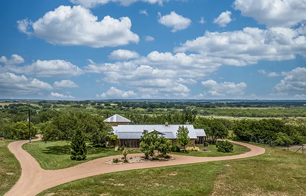
Many property features are best appreciated from above: swimming pools, circular driveways, landscaping, outbuildings, waterfront access, and architectural details that ground-level photography simply can't capture.
3. Creates Emotional Connection
Aerial photography evokes powerful emotional responses. The elevated perspective creates a sense of ownership and pride, helping buyers envision themselves in the space, which is crucial for motivating serious inquiries and competitive offers.
Property Types That Benefit Most
Aerial photography delivers the highest ROI for:
- Luxury estates and high-end residential properties
- Ranch and large acreage properties across West Texas
- Waterfront and properties with scenic features
- Properties with pools, outdoor amenities, or unique architecture
- Commercial real estate and development land in the Concho Valley
Best Practices
Timing and Lighting
Professional results require shooting during golden hour for warm, appealing light, in clear weather conditions, and with multiple angle coverage for comprehensive views.
Composition
Expert drone pilots understand real estate composition: establishing shots showing the full property, medium shots highlighting key features, detail shots of amenities, and contextual shots showing the neighborhood.
Return on Investment
The investment in professional aerial photography typically pays for itself. A listing that presents well can spend less time on the market, hold its asking price more firmly, and draw more qualified interest. In practice, that tends to show up as:
- Faster buyer interest, which reduces carrying costs
- More online inquiries from a stronger listing presentation
- More showing requests from buyers who already connect with the property
- A firmer negotiating position when the listing looks its best
The San Angelo and Concho Valley Real Estate Market
The San Angelo market has characteristics that make aerial photography particularly valuable. Large lot sizes, acreage properties, ranch land, and the region's dramatic terrain are all better communicated from the air than from the ground. Tom Green County properties frequently include significant outdoor features such as stock tanks, outbuildings, hunting blinds, improved pastures, and river or creek frontage that simply don't photograph effectively from ground level.
Waterfront properties along the North and South Concho Rivers, lakefront lots at Twin Buttes Reservoir and O.C. Fisher Lake, and rural acreage throughout Concho, Menard, McCulloch, and surrounding counties benefit enormously from aerial perspective. These are properties where buyers make emotional decisions based on setting and context, not just square footage. Aerial photography is the most effective way to communicate that context to buyers who may be browsing listings from Houston, Austin, or out of state.
Aerial Video vs. Still Photography: Which Do You Need?
Both serve different purposes in a real estate marketing package. Still photography delivers the highest-impact images for listing platforms like Zillow, Realtor.com, and HAR, where a buyer's first impression is a static image. Aerial video excels for social media marketing, YouTube property tours, and high-end listing presentations where you want to create an immersive, cinematic experience.
For most listings, a combination works best: 8–12 aerial still photographs for the MLS listing, plus a 60–90 second aerial video clip for social media and the listing description. We provide both as part of our standard real estate packages, delivered within 24 hours of the shoot.
Frequently Asked Questions
How long does an aerial photography session take?
A standard residential or acreage property shoot takes 45–90 minutes on site, depending on property size and the number of angles required. Edited, delivery-ready photos are typically returned within 24 hours of the shoot, fast enough to support same-week listing launches. Rush delivery is available when timelines are tight.
What time of day produces the best aerial real estate photos?
Golden hour, the hour after sunrise or the hour before sunset, produces the warmest, most visually appealing light for exterior real estate photography. For aerial work in West Texas, early morning also avoids the afternoon winds that are common in the region, resulting in more stable and sharper imagery. We plan shoots around these windows whenever your schedule allows.
Do I need aerial photography for every listing?
Not necessarily, but aerial photography delivers the clearest ROI for properties over half an acre, listings with significant outdoor features or amenities, waterfront and scenic properties, commercial real estate, and vacant land. For a standard in-town home on a small lot, traditional photography may be sufficient, though aerial context shots still add value to most listings by showing neighborhood proximity to parks, schools, and amenities.
Can aerial footage be used for social media and video tours?
Absolutely. We deliver footage in formats optimized for both MLS platforms and social media use. Aerial video performs exceptionally well on Instagram, Facebook, and YouTube, driving significantly more engagement than static photos alone. Many agents we work with use aerial footage as part of their general brand marketing beyond just specific listings.
Is aerial photography allowed in all areas of San Angelo?
Most residential and commercial areas in San Angelo and the Concho Valley are accessible for drone photography. Areas near San Angelo Regional Airport require prior FAA airspace authorization, which we handle through the LAANC system before every flight. Certain gated communities or HOA-managed properties may have access requirements we coordinate in advance. We handle all of this so you don't have to.
Why Choose a Certified Pilot
Professional real estate aerial photography requires an FAA Part 107 certified pilot, professional-grade equipment, real estate photography experience, and fast turnaround to meet listing deadlines. Concho Valley Aerial provides all of this, based right here in San Angelo, serving the entire Concho Valley and West Texas.
Ready to boost your listings?
Schedule Aerial Photography for Your Listings
See our real estate drone photography, based in San Angelo and serving all of West Texas.
Request a Quote